Rough Rock Parc
ROUGH ROCK PARK, in Les Preses, Gerona, Spain
It is located in a small, 1.700 inhabitants town named Les Preses, close to the Gerundean Pireneés. Is is a space of great interest called Bosc de Tosca, inside the premises of the Garrotxas Volcanic Zone National Park.
THE TOSCA FOREST
The tosca forest has a 210 Hs surface, and is a consequence of lava fusion from the Croscat Volcano, which erupted in 9.500 B.C.
This area has been colonized as a central-European forest, mostly by oak trees; this until the beginning of the XIXth. century, when due to a strong increment in population and the lack of food, wood and coal, deforestation was necessary. A colossal action of transformation took place, by removing the volcanic rocks to create small, cultivable fields, surrounded by dry-stone walls.
Throughout a century thousands of square meters of lava blocks were moved and piled, forming kilometers of winding walls, perfectly adapted to the slopes, and over 200 refuges were constructed using the same material.
Estimations go around 700 m3 of material per Ha. and over 150 Km. of mazy, winding walls.
Almost a 15% of the surface would have been occupied by walls or piles of volcanic rocks.
The whole area is connected by a endless network of paths surrounded by volcanic rock walls, that form a extraordinary mosaic of cultivable parcels.
All this has formed a very especial landscape, which is a unique humanized landscape.
In the beginning of the XXth. century this deforested area was an unusual, exceptional landscape. In 1918, a petition was made to declare it a National Park, which did not happen until 1982.
The impossibility of mechanizing these small fields, and their lack of profitability, forced their abandon. This very same abandon, plus their posterior inclusion in a National Park with a high level of protection (the 1982 Protection Law, the 1985 Especial Protection Plan), give little possibilities to the site. All of this has lead to a state of total abandonment, unknown to the very same people of the surroundings, and with a degradation process mostly due to:
-the peripheral growth of the city of Olot
-the performing of polluting activities
-uncontrolled, self-made constructions
-illegal dumpsters
Regulation and protection are interesting on a first stage, but sometimes they convey great contradictions, as they freeze the landscape, leading to its degradation; therefore, it is necessary to rethink, or reinvent, the landscape.
Following this strategy, in 1996 the administration of Les Preses came to us requesting a study, to see how this evident can be activated and recovered as a social good, to make it evident, to use it.
The capacity of this small municipality on an interventional level is practically nil, so it was considered to make a proposal to the environmental program LIFE, and its help was granted:
It is a program of technical and financial assistance, obtained from the financial funds of the European Committee, destined to experimental and innovative actions in the integration of environmental, economical, developing and territorial planning subjects.
The Rough Rock Park Project intends to develop the demonstrative effect of the restoration and recovering of degraded spaces, aiming to improve the quality of the Landscape in an area of high and diverse values through sustainable resource exploitation, under the following purposes:
- to create the conditions so this protected area can make its values evident, by means of a sustainable resource exploitation.
- to make this action an expansive source of recovery, not only within the tosca forest but also in other European frames of similar characteristics.
- to create a model of cooperation between public and private entities, in order to convert degraded, slummed, peripheral areas into spaces of ecological, social and cultural fulfillment.
- to obtain a demonstrative dimension through an elevated number of visiting public and researchers, from a local and an European ambit, by means of the exploitation of the interest of the Park, its geographical situation and its supporting institutions.
PROPOSAL
Basically, it is formed by two levels of intervention, one not visible, the other one visible.
NON-VISIBLE INTERVENTION
Non-visible, because it is a delicate, meticulous intervention, that discovers and enhances the inner values of the site. The architecture is formed by the trees, the bushes, the vegetation, the stones, the textures, the grain.
1. The project proposes to visualize and recover the space, cleaning it from invasive and spontaneous vegetation, reinforcing its rough character and the vision of the great human effort of the accumulation of rocks. In this stage, the place is rediscovered; it has nothing to do with cartography, there is a demand to change the itineraries. The proposal is made and remade in situ. Enhancing, redefining the spaces of higher interest, simply removing a tree, planting new ones, planting bushes,
Paths with different textures.
2. Rehabilitation and restoration of this cultural site. Refuges and rock walls are rehabilitated, almost 70% of the currently existent.
3. Recovery of the autochthonous agricultural activity (in around 50 parcels), by means of the growth of traditional, endangered local products, precisely those that do not follow the logics of profitability. Their selection is done taking into consideration their environmental benefits (gastronomical, pedagogical, ecological and landscaping).
Around 60% of the crops are in a way to totally disappear from the region. The use of biological agriculture is introduced, and an origin denomination is encouraged.
To achieve these activities, a water irrigation system that provides the conditions of implementation is proposed.
VISIBLE INTERVENTION
Visible, as it takes care of the introduction of humanized elements of different will and use, and these are, mainly, to appreciate the harsh and unusual beauty that Mossèn Gelabert used to tell us about, for which, with our action, the visit is encouraged for environmental, ecological, pedagogical and landscaping reasons
as well as for the global, sustainable development of the district. The project seeks to enhance the singularity of this landscape and to activate the factor of surprise in its discovery.
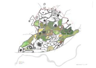
1. For this, ITINERARIES are created, in order to allow walking through the area fully or partly. Four itineraries, of different lengths, are established, searching for the best views, terrains, grains, with a total of 33 focus points.
2. A system of SIGNALIZATION is established, which allows to follow the paths autonomously in spite of the mazy character of the site, and with their own expression and materiality, in order to make the defined paths effective. They become stops or filters, breaks in the path, frames that must not be missed.
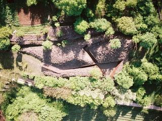
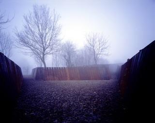
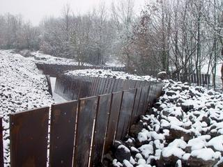
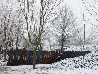
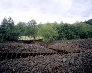
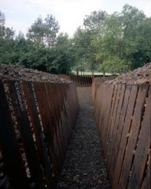
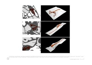
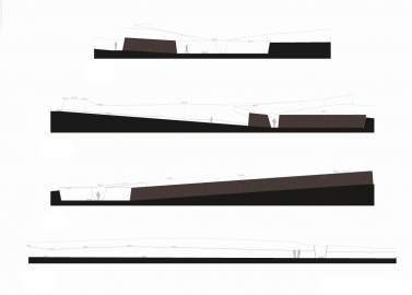
3. The ACCESS and its approach are recreated. It has been settled to access from a point that departs from a bici-track (the old carrilet track), by which there is no automobile access (coaches and cars park at a distance of a 5 min. walk), and this alone provides a visual approach to the landscape. It is at this point where a more architectonical intervention is realized, by means of the creation of an open-air space that becomes a reception room and doorway towards the park. It stages the effort realized, through the retention of the rocks by the half-open steel planks.
This more defined intervention in the access point stands for the creation of a preamble space that breaks with previous experiences and initiates a path without constructed interventions. This access point towards a rocky world materializes as lava flows that run towards a hole; it presents itself as a period point and as a mid-point, first from what has been lived, and second from what you will be able to discover and feel. Its edged, triangular geometry, and its steeled material, composed-decomposed, are a counterpoint, in balance with the smug shapes of the volcanic rocks. It predisposes to the discovery of a singular landscape, harsh, beautiful, volcanic, unknown, humanized
so you can attempt to write down its poetry as Gelabert did his own.

